ATLAS: High Density, Enterprise-Wide Asset Tracking

Description
ATLAS (Accurate Tracking & Locating Asset Solution) software wirelessly and precisely locates and tracks tagged items in densely packed metallic environments in real time. Through a mobile or desktop app, users can easily log items to assets and track them throughout the entire facility and beyond.
Users can associate work-order or part numbers to tags instantly and track them throughout their entire manufacturing cycle on the floor. The search function snaps to the tag being searched across the entire mesh for easy retrieval or process step identification in real time. The solution provides continuous tracking, even through walls and obstacles with low power requirements and configurable battery life. The WISER Locator can also operate in concert with existing asset tracking systems like barcodes or RFID and can be scaled for nearly any number of tagged assets or size of setting.
The micro-location system uses ultra-wideband (UWB) technology to locate, identify, and track assets and works for Industry 4.0 priorities including smart manufacturing, operations improvement and efficiencies, warehouse and auto-inventory management, supply chain and logistics, occupancy and visitor tracking, and yard management, to name a few. The antenna nodes and tracker tags communicate with one another to establish a wireless mesh. The tracking software then calculates inch-level tag coordinates from these signals, overlaying live, real-time asset locations on a site map or floor plan, continuously and autonomously locating any in-mesh asset affixed with a WISER tag. Real-time data can also be integrated into software systems using WISER's API or into virtually any database using WISER's direct-to-database linkup feature.
Specs
- Delivers sub-meter and centimeter-level precision
- Locates and tracks accurately in complex, reflective, and metal-filled environments
- No line of sight needed. Operational range extends above 164 ft (50 m) line-of-sight and 65 to 130 ft (20 to 40 m) through multiple walls or other obstacles
- Calibrates autonomously
- Scales modularly to nearly any size, configuration or number of assets
- Allows cloud-based or on-premise solutions
- Can operate inside or outside firewalls for added security
- Operates 24/7 without Wi-Fi, cellular or GPS
- IC compliant with IEEE802.15.4-2011
- FCC and ISED (IC) certified
- Self-corrects for unplanned movement of antenna infrastructure while the system is operating
- Allows asset naming, labels, and searches
- Enables users to create zones/geofences at any point on a site map or floorplan
- GPS-staking features translate in-mesh coordinate data into latitude/longitude
- Displays tracking histories with playback options
- Database linkup feature allows direct connection to virtually any database
- Mobile and web-based applications
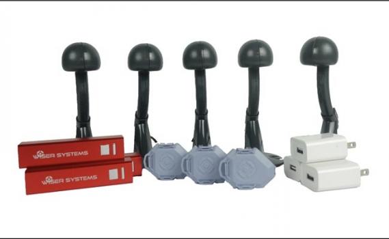
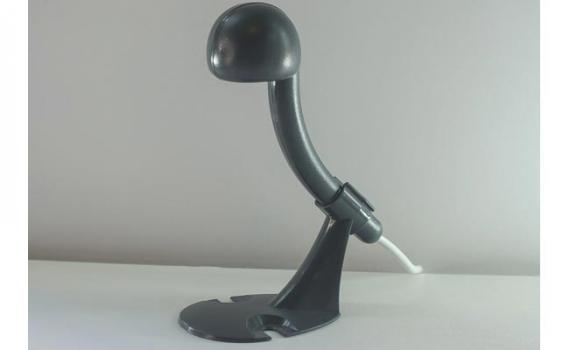
Antennas:
- Node dimensions: 6 x 2 x 1 in. (152 x 50 x 25 mm)
- Node weight: 40 to 45 g
- Antennas can be powered via a USB port, battery, wall outlet or PoE
- 110 mA current
- 5V power draw
- Operates indoors and outdoors
- Easy installation and adjustment
- Antennas can also be set to tracker mode, doubling as high update-rate tags
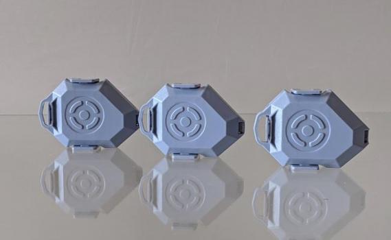
Tags:
- Tag dimensions: 1 x 1.5 in. (25 x 38 mm)
- Programmable ping rates up to 8 Hz
- Tags enter power-saving sleep mode when motionless, lengthening battery life exponentially
- Two-way data transmission capability provides status updates in real time even for tags in sleep mode
- Data transfer rates up to 6.8 Mbps
- Operates at ultra-low power (microwatts) for extra-long battery life
- Operates on replaceable coin cell batteries
- Battery life programmable from 1 to 10 years
- Sends real-time power updates, alerting user before a battery fails and needs replacement